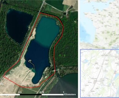
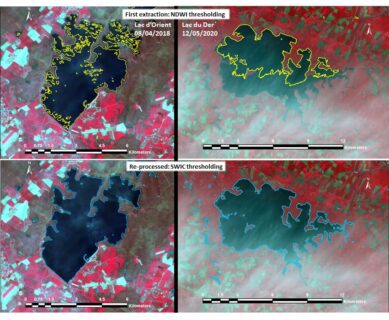
Sertit

Uncategorized Sertit 

Carte due du ciel

API REST for ICube-SERTIT’s Rapid Mapping resources

ICube-SERTIT’s catalogue of rapid mapping actions is now accessible through a read-only REST API. In order words you can view our rapid mapping assets through a machine friendly interface. For instance the complete catalogue of public rapid mapping actions is accessible through the following URI: https://sertit.unistra.fr/wp-json/rms/v1/actions Issuing a HTTP GET request on this address will […]

Fitri Lake Water Extent

LWE derived from Sentinel-2 time series, ICube-SERTIT processing ExtractEO, an automatic water detection workflow developped by ICube-SERTIT, was applied to the Sentinel-2 time series covering Fitri Lake from January 2017 to February 2021, deriving a lake mask for each Sentinel-2 acquisition date. The ExtractEO pipeline downloaded 246 Sentinel-2 images from the CREODIAS platform and detected […]

Carte due du ciel

AFNOR CERTIFICATION RENEWAL

AFNOR Certification has renewed ICube-SERTIT’s Rapid Mapping Service ISO 9001:2015 certification for the next 3 years, for its « Production of crisis and emergency geo-information for civil protection, defence, security, and insurance sectors with publication within strict delays after satellite data reception ». With this success in mind, ICube-SERTIT will endeavor to integrate all of its activities […]