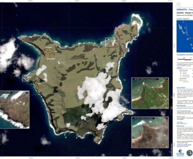
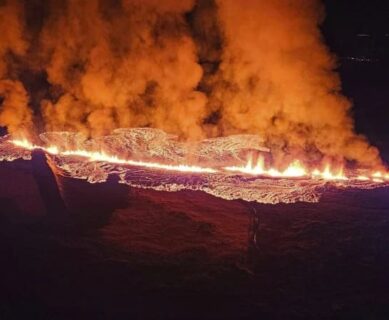
• en
  • fr
  • Sertit

    Uncategorized Sertit 

    Anomaly detection with deep learning to delineate wildfires in SPOT-6/7 images

    Wildfires have grown increasingly prevalent, causing significant socio-economic and environmental damage. As a result, the emphasis on efficient detection and delineation of fire events has driven the development of novel methodologies and techniques over the years. Reflecting this trend, SERTIT’s intern, Oscar Narvaez worked on an exploratory project during summer 2023, aiming to assess the potential […]

    Région de Karkhova

    The collapse of the Kakhovka dam seen from satellite imagery

    Context The Kakhovka hydroelectric dam in northern Ukraine has been the target of attacks, causing it to burst on 6 June 2023. Unprecedented flooding hit towns and villages as far downstream as the mouth of the Dnieper, forcing thousands of people to quickly evacuate. As well as producing electricity and supplying drinking water, the dam […]

    Occurences en eau du lac Argyle

    Lake Argyle Water Extent

    Lake Water Extents derived from Sentinel-2 time series, ICube-SERTIT As part of the  CCI Lakes  project, ExtractEO, an automatic water detection workflow developed by ICube-SERTIT, was applied to the full Sentinel-2 time series covering Lake Argyle, Australia, from January 2016 to August 2022, deriving a lake mask for each Sentinel-2 acquisition date at 10m ground […]

    Carte due du ciel

    ISO 9001 CERTIFICATION OF SERTIT’s ACTIVITIES

    SERTIT’s Rapid Mapping Service (RMS) has been ISO 9001 certified since 2011 for the production of crisis and emergency geoinformation under time constraints. This is a guarantee of quality and conformity of the products and services provided with respect to the specifications of its customers. Leveraging its 11 years of RMS certification, SERTIT decided in […]

    EOReader

    Introduction to EOReader

    Introduction to EOReader, a remote-sensing open source Python library developed by SERTIT to tackle rapid mapping challenges. Context As one of the Copernicus Emergency Management Service Rapid Mapping and Risk and Recovery Mapping operators, SERTIT needs to deliver geoinformation (such as flood or fire delineation, landslides mapping, etc.) based on multiple EO constellations. In rapid […]

    Examples of image re-processing adopting as threshold SWIC=0, to improve the extraction which failed due to NDWI values altered by the presence of cirrus

    Extraction of water surfaces over the Grand-Est with ExtractEO

    Water and its management are crucial issues, especially in times of climate change and biodiversity loss. In this context, water surfaces such as lakes are particularly interesting areas. Earth observation data is playing an important role in assessing and monitoring this resource. The scientific community, with the development of dedicated satellite missions such as SWOT […]

    Location of the gravel pit of Nordhouse (Grand-Est, France)

    Case study: water surface time series of a gravel pit

    In the frame of the study of the dynamics of water bodies in the Grand-Est region (France), the water surface time series for the gravel pit in Nordhouse (next to the Plan d’Eau de Plobsheim) has been produced. This was made possible through the use of the ExtractEO processing chain. The accuracy of the analysis […]