

Presentation of geoprocessing methods inspired by specialized data-visualization journalism in security applications.
Introduction
Recent conflicts are scrutinized by many observers, both in terms of information collection and its processing. Journalists are at the forefront of these methodological shifts. Field reports, crisis communication, articles and in-depth analyses, social media… The mass of open-source data is fertile ground for analysts, who cross-check it in order to shed light on and verify their topics from different angles.
Without denying the existence of blind spots that in-depth source cross-checking does not always make it possible to reveal, as illustrated by the difficulty of obtaining information on the conflict in Sudan (Kostika 2026), the sheer volume and technical nature of these data stand in the way of a clear reading of situations (Figure 1). It is therefore necessary for SERTIT to develop tools for aggregating and synthesizing reliable sources, in order to limit the pitfalls of informational noise (Gayard 2022), while also incorporating elements of methodological advances from data journalism.
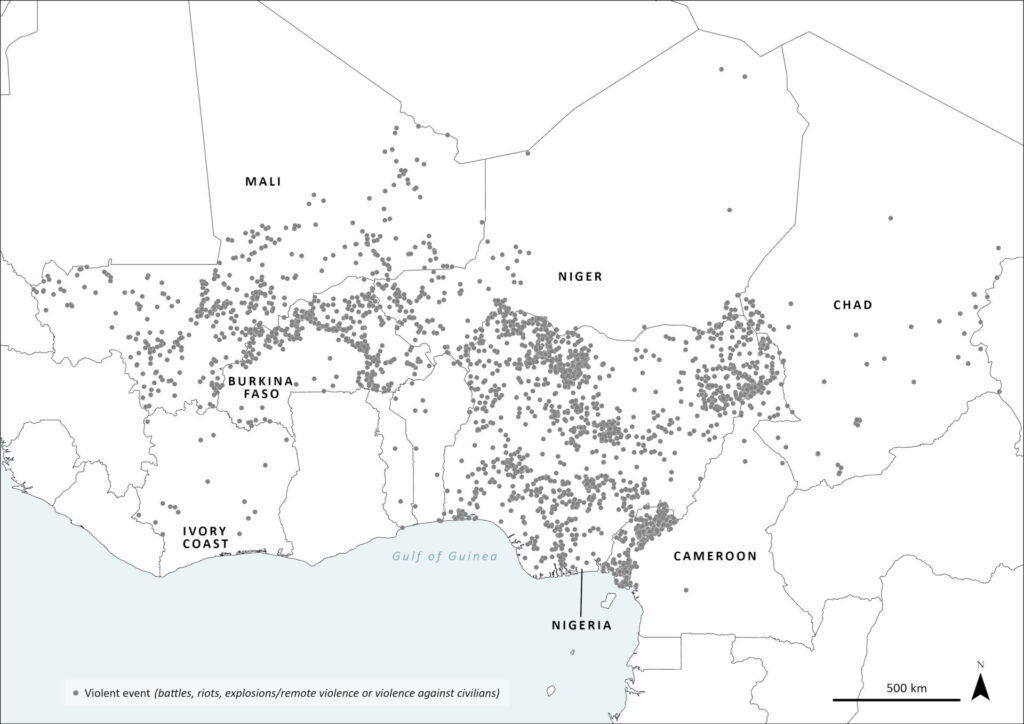
Many points overlap, as they are located at the same coordinate (map by Cléa Péculier, source: ACLED).
Context
Within the scope of its activities in geospatial security, SERTIT produces reports and maps describing security events in several crisis zones around the world. The service therefore cross-references several sources to make its analyses more reliable, among which the NGO Armed Conflict Location & Event Data (ACLED) is an essential source.
In order to support the responsiveness of the analysts responsible for implementation, the service has equipped itself with tools for processing this data, drawing on approaches from data journalism. These cover raw processing, data aggregation according to criteria, adoption of a data model, and cartographic representation.
Two objectives accompanied the development of these methods in particular:
- To provide a readable and understandable output, inspired by press productions, thanks to the journalistic skills of the engineer in charge of development.
- To reduce the technical burden while preserving the analyst’s room for maneuver by giving them fine-grained parametric control, if desired. Contrary to several current trends, the service does indeed want to guarantee the human character of the analysis provided.
Methods
One recurring need is the analysis of the distribution of casualties from violent events and of the actors involved, within a given spatio-temporal framework. The data used are geolocated tables supplemented by ACLED, containing unique events in quantities that can reach several hundred thousand records.
The first processing chain calculates, by locality (the reference unit for the NGO’s georeferencing), the total number of deaths that occurred in violent events (Figure 2). This makes it possible to provide an initial analysis of insecurity situations by examining the areas of violence located near inhabited areas, as well as their hotspots. In the same way, these results can also give us an indication of a belligerent’s main line of effort by analyzing the number of military casualties in a key sector within the framework of a maneuver.

The second processing chain focuses on the spatial footprint of the various actors or groups of actors involved in a security situation (Figure 3). The tool makes it possible to clearly determine the involvement of actors in violent events as well as their area of action. While leaving it to the analyst to select the objects of study, the tool is designed to take into account the complexity of conflict faction dynamics. Indeed, these actors may appear in different states, depending on the period or even the area:
- in transition, such as the private company Wagner, which became Afrika Corps, a unit of the Russian Ministry of Defense,
- allies one day and enemies the next, such as armed groups in Mali,
- reconstituted or changing allegiance, such as the Syrian armed forces before and after regime change,
- split into factions, such as Boko Haram’s historical group (Jama’atu Ahlis Sunna Lidda’adati wal-Jihad, JAS) and the Islamic State West Africa Province (ISWAP) (Crisis Group 2024).

Results: case study on armed groups in sub-Saharan Africa
These tools made it possible to generate an initial overview of the security situation in part of the Sahel during the first months of 2026. The region is experiencing a crisis that continues to grow (UNOCHA 2026), marked among other things by violence, conflict, and political instability, placing millions of people in situations of vulnerability and insecurity.
Indeed, sub-Saharan Africa, and the Sahel in particular, has become over the past decade one of the epicenters of terrorism (IEP 2026). In 2025, the region accounted for more than half of all terrorism-related deaths (UN 2025) and hosted the two deadliest terrorist organizations: the Islamic State (by its subgroups ISWAP and ISSP), and Jama’at Nusrat al-Islam wal-Muslimin (JNIM).
Thus, Figure 4 summarizes the distribution of casualties resulting from violent events in the central Sahel and neighboring countries between 1 January 2026 and 15 May 2026. The size of the circles depends on the number of people killed, by locality. However, symbol overlap can hinder analysis, as some of the information is masked. By adding a styling effect, overlapping symbols become darker, allowing density to be represented effectively despite the overlap of entities.

Figure 5 depicts the areas of action of four actor groups predefined by the analyst, in the central Sahel and neighboring countries, between 1 January 2026 and 15 May 2026. Each actor is represented by a color: if a grid cell is a single color, it means that only one of these four actors was involved in events in that area; if it is hatched with two different colors, then two of these four actors were involved in violent events in that location. Gray cells indicate areas that experienced this same type of event during this period, but in which none of the four highlighted actors were involved.

Conclusion and outlook
Why present these tools? Because they are practical, operational, and their ergonomics make them everyday tools for engineers involved in SERTIT’s security applications. Equipping ourselves with new tools means ensuring access to a range of “off-the-shelf” capabilities that are responsive and maintain control over sources and processing.
As international news regularly reminds us, security issues are changing and multifaceted (WEF 2026). It is therefore necessary to be prepared to cover these new forms while keeping these processing chains adaptable. One planned development would be to complement the spatio-temporal analysis via GIS (geographic information system) by strengthening the statistical modules. The aim would thus be to make geographic analysis interact more deeply with graphs, following in the footsteps of many thematic works by infographic designers and journalists.
An article by Cléa Péculier and Hugo Regad.
3 July 2026
Bibliography
Crisis Group 2024. Collectif, Africa Briefing N°196, Crisis Group, 28/03/2024, https://www.crisisgroup.org/fr/brf/africa/west-africa/nigeria/b196-jas-vs-iswap-war-boko-haram-splinters
Gaillard 2022. L. Gaillard, OSINT : le nouveau champ de bataille de l’information de source libre, Conflits, 21/10/2022, https://www.revueconflits.com/osint-le-nouveau-champ-de-bataille-de-linformation-de-source-libre/
IEP 2026. Collectif, Global Terrorism Index 2026: Measuring the impact of terrorism, IEP, 01/03/2026, https://www.economicsandpeace.org/wp-content/uploads/2026/03/Global-Terrorism-Index-2026-Report.pdf
Kostika 2026. E. Kostika, Sudan, the black hole of journalism, 04/02/2026, IMEDD, https://lab.imedd.org/en/sudan-the-black-hole-of-journalism/
UN 2025. Collectif, L’Afrique, « épicentre du terrorisme mondial », ONU Info, 21/01/2025, https://news.un.org/fr/story/2025/01/1152321
UNOCHA 2026. Collectif, Sahel Dashboard – Humanitarian Overview (As of 29 April 2026), UNOCHA, 06/05/2026, https://www.unocha.org/publications/report/burkina-faso/sahel-dashboard-humanitarian-overview-29-april-2026
WEF 2026. M. Elsner, G. Atkinson, S. Zahidi, Global Risks Perception Survey, 2026, https://reports.weforum.org/docs/WEF_Global_Risks_Report_2026.pdf